History of Ryde
Settlement
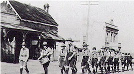
Photo: 1st North Scout troop marching down Coxs Road, past the School of Arts and Horton's shop, North Ryde, around 1924.
On the 3rd January 1792, the first land in the Ryde area was granted to eight marines, along the northern bank of the river between Sydney and Parramatta. The area was named by Governor Phillip the 'Field of Mars', Mars being the ancient God of war, named to reflect the military association with these new settlers. Today's Field of Mars Reserve is the remnant of a district which once extended from Dundas to the Lane Cove River. These grants were followed soon after by grants to ten emancipated convicts in February 1792, the land being further to the east of the marines grants, thus the area was called Eastern Farms or the Eastern Boundary. By 1794 the name Eastern Farms had given way to Kissing Point, a name believed to have originated from the way in which heavily laden boats passing up the Parramatta River bumped or 'kissed' the rocky outcrop which extends into the river at today's Kissing Point.
Further grants were issued in 1794 and 1795, gradually occupying most of the foreshores between Meadowbank and Gladesville.
Some of the grants were at the North Brush, north of the Field of Mars settlement, in the area of Brush Farm and Eastwood. Most of the Grants were small, from thirty to 100 acres.
By 1803 most of the accessible land had been granted. Settlement was based along the Parramatta River and overlooking ridges. Governor King recognised that most of the smaller settlers had insufficient land for their stock but it was not possible to grant them larger allotments. In 1804 it was decided that a 'traditional English common' - a large area of public land for use by local inhabitants - would be set aside. Six commons were gazetted.
The Field of Mars Common, an area of approximately 5,050 acres located north of the Field of Mars and the Eastern Farms, covered most of the Ryde municipality. The village itself comprised only a modest scattering of houses in a few streets around the church, surrounded by farms, orchards and some large estates. Nevertheless the name was well-established by 12 November 1870 when the Municipal district of Ryde was officially proclaimed.
Suburbs
Ryde
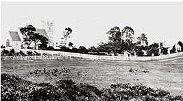
Photo: Looking at the village of Ryde and the old Wesleyan Chapel, from below St Anne's Church, around 1863
 By 1841 the new name, Ryde, was emerging for the district. It derived from Ryde on the Isle of Wight and first appeared on a subdivision plan for the proposed village to be created around St. Anne's Church. The English Ryde was the birthplace of Mary Turner, the wife of the vicar of St. Anne's, the Reverend George Turner, and also of George Pope, Kissing Point's first postmaster.
Denistone
Gregory Blaxland, a free settler, purchased the 450 acre Brush Farm estate in 1806, shortly after his arrival in the colony. This estate covered most of the area south from Terry Road to Victoria Road and Tramway Street, and east from Brush Road to Shaftsbury Road. In 1829 Blaxland transferred Brush Farm Estate to his eldest daughter, Elizabeth, and her husband Dr Thomas Forster. Forster expanded the estate by purchasing the Porteous Mount grants of 120 acres on the Denistone ridge in 1830. Denistone was called after Forster's home "Dennistone", burnt down by bushfires in 1855. Richard Rouse Terry acquired the land from the Blaxlands in 1872 where he rebuilt Denistone House. The Denistone estate, centered on Denistone House, was a late subdivision, not opened up for sale until 1913.
Eastwood
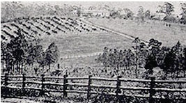
Photo: Looking across Eastwood Estate towards Eastwood House around 1880
 The hill to the east of Brush Farm was purchased by Dr. Forster's nephew, William Rutledge in 1835. He named it Eastwood and in 1840 built a single storey house with views across to Brush Farm and down the Eastwood Valley. Edward Terry, Richard Terry's brother, purchased the Eastwood Estate in about 1863. In 1871 Edward Terry was the first Mayor of Ryde in 1871 serving three terms in municipal office, and later served as the local member of parliament from 1898 to 1904. Eastwood Village emerged with the subdivision of Edward Terry's Eastwood Estate, begun in 1905, after his death. The house became St. Kevin's presbytery in 1929 till it was handed over to the Marist Brothers school in 1968. The suburb Eastwood gets its name from the Eastwood Estate and house.
Gladesville
One other part of the district with the status of village was Gladesville, created by the 1856 subdivision of land that had belonged to John Glade. Glade had arrived in New South Wales as a convict in 1791. He bought land from Richard Paterson, land that was originally granted to John Doody, then extended his holdings by another acquiring 50 acres, 60 acres in all. By 1802 Glade had developed a well-established farm fronting Glades Bay. Following John Glade's death his rural land holding was subdivided into urban lots by a developer who honoured him by naming the area Gladesville.
Meadowbank
Land originally granted to Surgeon William Balmain in 1794, in the district of the Field of Mars, was given the name 'Meadow Bank'. Balmain returned to England in 1801, leaving his estates to be managed by fellow surgeon D'arcy Wentworth. Wentworth agreed to sell Balmain's grants to John Bennett, an ex-convict who had been transported in 1795. By 1819 both the 'Meadow Bank Estate' and 'Chatham Farm' to the north, belonged to Bennett. In 1823 he was joined by his nephew William Bennett. John Bennett died in July 1829, a bachelor, and his nephew inherited his estate, building Meadowbank House around 1835. William then sold 'Chatham Farm' to Major Edward Darvall in 1855. William Bennett died in 1865 but his widow remained at Meadowbank until her death in 1879. The estate was subdivided in the late 1880's, given impetus by the opening of the railway from Strathfield to Hornsby in 1886.
North Ryde
North Ryde was, until well into the nineteenth century, part of the Field of Mars Common. The district's first school, which opened in Cox's Road in 1878, was known initially as City View. The school's name was changed to North Ryde in 1879. The post office, which opened in 1885, has always been known as North Ryde.
West Ryde
Land was granted in the West Ryde area in 1798 and 1799, these were part of the Meadowbank grants. Major Edward Darvall purchased land in 1849 and built Ryedale House and surrounded it with orchards. The land stayed in the Darvall family until the early 1900s when it was subdivided after the death of Edward Darvall's second wife Jane. It was the decision to locate the railway station at West Ryde that resulted in the area's development as a suburb. The railway from Strathfield to Hornsby was opened in 1886.
Bibliography
- A basic history of Ryde, 1792-1964 Ryde: Ryde Historical Society, 1966
- Focus on Ryde: a local studies resource Ryde: Ryde Bicentenary Schools & Youth Task Force, 1992
- From bush to suburbia: pioneers of Ryde, Volume 1 Edited by Julie Dawson. Ryde: Ryde Bicentenary Celebrations (Historical) Task Force, 1992
- Jonathon Falk Planning Consultants Pty. Ltd. in association with Rodney Jensen and Associates Pty. Ltd. Ryde Heritage Study : inventory volume : final report. Two volumes. Bondi Junction: Jonathon Falk Planning Consultants, 1988
- Levy, M.C.I. Wallumetta : a history of Ryde and its district, 1792 to 1945. Ryde: Ryde Municipal Council, 1947
For further information please contact the Local Studies Librarian on 9952 8353 or email rydelibrary@ryde.nsw.gov.au.